Explore the best places
Discover new places in Montalegre
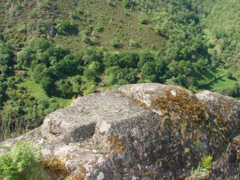
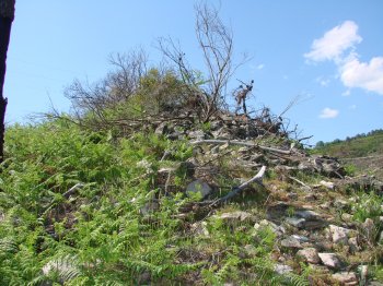
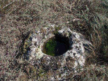
Povoado de Monte de São João
- heritage
Ferral
5470-122, Ferral
The slope of the Mount of São João, relatively close to the "Table of the Moors", in an elongated platform that ends in the escarpment Rabagão, gathered fragments of "tegullae" and a half tile. Currently, in addition to these indications, are not percetíveis other archaeological remains. On site existed until a few years ago a stone with a hole at the top, where, according to oral tradition, if I prayed the mass, serving the cavity to put holy water. Next to location, in the place called "Mesa dos Mouros" lies a granite outcropping carved in the shape of the table …
Mamoa de Campo da Armada
- heritage
Campo da Armada
5470-160, Gralhas
This is a funeral, reasonably visible megalithic monument, with about nine meters in diameter maximum and partially severed by a path. Do not identify mainstays to the surface. This monument has recently been drawn up, which resulted in the appearance of smooth ceramic fragments.
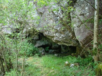
Pala dos Mouros
- heritage
Fiães do Rio
5470-151, Fiães do Rio
Moorish patch consists of a large granite monolith that form a large cavity with rounded surface. The only opening is facing This, namely to the Cávado. This site brings together all the features to have been a potential shelter of human population, in various stages of prehistory, however, will require archaeological work demonstrating the occupation of the site. It is a large shelter, very protected from the weather with a water line.
Povoado de Ciada
- heritage
Gralhas
5470-160, Gralhas
Traces of a Roman settlement located southwest of Rooks, taking as a reference point the football field, approximately 950 meters above sea level. No sense surface structures, however Roman chronology materials abound. The village was partially cut in at 508. A wide area are fragments of "tegullae" and common Roman pottery, as well as granite blocks from old buildings. Some archaeologists associate this village to mining next dali as well as a bypass road of disposal of precious materials.
Castro de Ferral
- heritage
Ferral
5470-122, Ferral
Fortified settlement located on a hill on the right bank of the River, Rabagão on Mount of Balaselas, Ferral. Visible are two lines of wall on tip, being more evident on the northwest side. Here is also a deep moat, entirely carved into the rock. Inside the castro there are alignments of indigenous structures and ceramic micácea. Some of these fragments are found in the Ecomuseum of Barroso.
Mamoa da Baixa do Monte Gordo
- heritage
Aldeia Nova de São Mateus
5470-173, Meixedo
Megalithic monument of difficult visibility, partially cut off by the construction of the road. It is located at the intersection of the roads connecting to the new village of São Mateus, Firvidas, and Zadjalooooo Gralhós, coming from Meixedo. Presents about ten meters in diameter maximum and a very sharp central depression, from which emerges a mainstay. In the surrounding area there is enough gravel, possibly belonging to the breastplate monument petraea.
Mamoa de Marouco da Raposeira
- heritage
Lamachã
5470-321, Negrões
In the middle of the pedestrian path of the Alto Rabagão, rail in place "Marouco da Raposeira" is a megalithic monument, partially cut by the way. Is a high bit prominent, still preserves remains of lytic Cuirass and detects significant central depression or anchor to the surface. Has about 10 meters in diameter and is covered by pine trees. This is actually more a funerary megalithic monument, which can be almost intact.
Castro de Negrões
- heritage
Negrões
5470-322, Negrões
Fortified settlement of little breadth, located in the same row of the castros de Vilarinho de Negrões and Morgade, dominating, together, the whole valley of Rabagão. Retains a thick wall, surrounding the mound, and that in some points is about five feet thick. Inside, there are traces of buildings. At the top of Mount was placed a high tension pole cut partially to wall. East side access would be easier, and it is this location which will have built a moat, of which traces still remain.
Povoado de Muradelhas
- heritage
Muradelhas
5470, Montalegre
Ancient Roman settlement located at the place called Muradelhas, about 1.5 kilometres of Montalegre, just over 1000 meters of altitude. This is a high bit evident, currently covered by a dense undergrowth. Are still visible two thick walls and inside wide platforms where identifying alignments of structures. Throughout the town were found fragments of Roman pottery.
Castro de Morgade/ Coroa do Castro
- heritage
EM525
5470-304, Morgade
Fortified village, with a thick line of surrounding wall, built with Earth and pebbles, in partial ruin. The most obvious traces of this town are focused on the line of Hadrian's wall, with about 6.5 meters wide. Inside the village does not detect ceramic materials to the surface. Deploys on the northern slope of the serra do Barroso at the beginning of vale do Rabagão, on its left bank. Fortified settlement of small size. Inside the granite outcrops abound, some of which form natural shelters.
